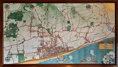
Max Gill: Wonderground Man – the most recent exhibition at Ditchling Museum of Art – which ended in April this year – attracted a host of visitors, both seasoned enthusiasts as well as newcomers to Max’s work. It’s always wonderful to see how people of all ages are attracted to the various maps and other works, often finding their own personal links to the places or events that are illustrated. One of the simplest but certainly the most powerful of all the exhibits was the military headstone. This never fails to make people pause and think, not just about the art behind the stone but also about the Great War – and subsequent conflicts – that it symbolises.
The W.H. Smith Map
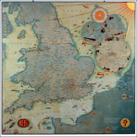
The most exciting event of the Max year took place in April at Chorley’s, an auction house near Cheltenham that was given the task of selling a collection of items owned by the W.H. Smith Trust. Amongst a miscellany of shop signs, paintings and art deco furniture, was the 7ft
3in (2m 21cm) square painted map Max completed for the firm in 1931.
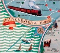
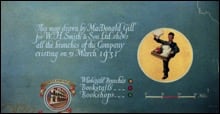 The W.H. Smith map reflects the company’s illustrious heritage as the number one stationer on British high streets. It was commissioned in 1929 by the firm’s chairman Charles H. St. Hornby and director Arnold D. Power soon after W.H. Smith & Son had changed from a partnership to a private limited liability company. As well as the bookstalls, wholesale branches and bookshops, it depicts the range of newspaper delivery methods used by the firm which still included horse drawn vehicles. The map also shows the newly-opened branch in Brussels as well as the W.H. Smith bookshop and tearoom on the rue de Rivoli in Paris where an Englishman could buy his daily paper. The fascia boards of the Paris branch were painted in 1904 by Max’s brother Eric (possibly with Max’s assistance). They would have travelled over on the boat-train but in 1931 they could have flown to the French capital on The City of Glasgow, the plane depicted on the map over the French coast. Operated by Imperial Airways, this was the first luxury London to Paris service.
 The map was installed in the W. H. Smith headquarters at Strand House in London in 1931. According to his payment ledger, Max was paid a total of £765 – around £42,000 in today’s money – a small fortune. When the firm relocated to Swindon, the panel was hung in the staff restaurant where I first saw it a decade ago. Here it was seen by employees every day – I understand they were very sorry to see it go. The day before the sale I travelled down to Chorley’s – with Max’s grand-daughter Anne – to see the map, which was clearly the showpiece of the sale. I was reminded how impressive it was and how much delightful detail I had forgotten – the vehicles of course, but also the shoals of plaice, mackerel and cod in the waters around the British Isles. The following day I sat at my computer screen and watched a bidding war unfold with the price of the map rising ever higher. But eventually it was over with the hammer going down at an eye-watering £50,000!
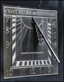 Charles St Hornby (1867-1946), who joined W.H. Smith & Son in 1893, had a consuming passion for fine printing. He set up the Ashendene Press (1895-1935) in a disused stable at the bottom of his Chelsea garden where he printed limited editions using vellums, the finest papers and inks as well as a typeface made by Emery Walker and Sir Sidney Cockerell. It was St. Hornby who commissioned Eric Gill to design the W.H. Smith lettering in 1904 – the original lettering sheets sold at the Chorley’s sale for £16,000. Max’s diary reveals that he assisted Eric with the painting and gilding of the lettering of some W.H. Smith shop fascia boards. Also, in 1921 Max designed, painted and gilded a slate sundial for St Hornby’s 17th century manor house of Chantmarle near Dorchester in Dorset.
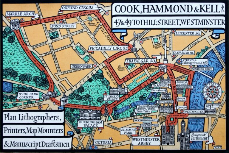
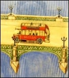 Fellow director Arnold Danvers Power (1875–1959) commissioned a painted map panel from Max in 1924. Power lived in Dean Trench Street – shown on the map – and driving across Westminster Bridge is a London bus displaying an advertisement for W.H. Smith & Sons (rather difficult to see in the picture, but take my word!). There’s more about this map in the Spring 2016 Newsletter (in the MacDonald Gill website News archive). These days the map hangs at the bottom of the staircase in the reception area of the City of Westminster Archives Centre – if you’re in the area, do pop in and take a look.